Sunnyside Flood Barrier
Sunnyside Flood Barrier Project
We're investing in Sunnyside, Hillhurst and along the Memorial Park Corridor to increase flood resiliency and create spaces that enhance the connection with the river, community and natural environment, while commemorating our heritage.
About the project
We know that building a permanent flood barrier is vital to help protect people, homes, and businesses in Sunnyside and Hillhurst from river flooding. We are committed to delivering a 1:100 level flood barrier. This will help us manage flood water and avoid the type of damage we saw in 2013, while providing the building blocks for future climate resiliency.
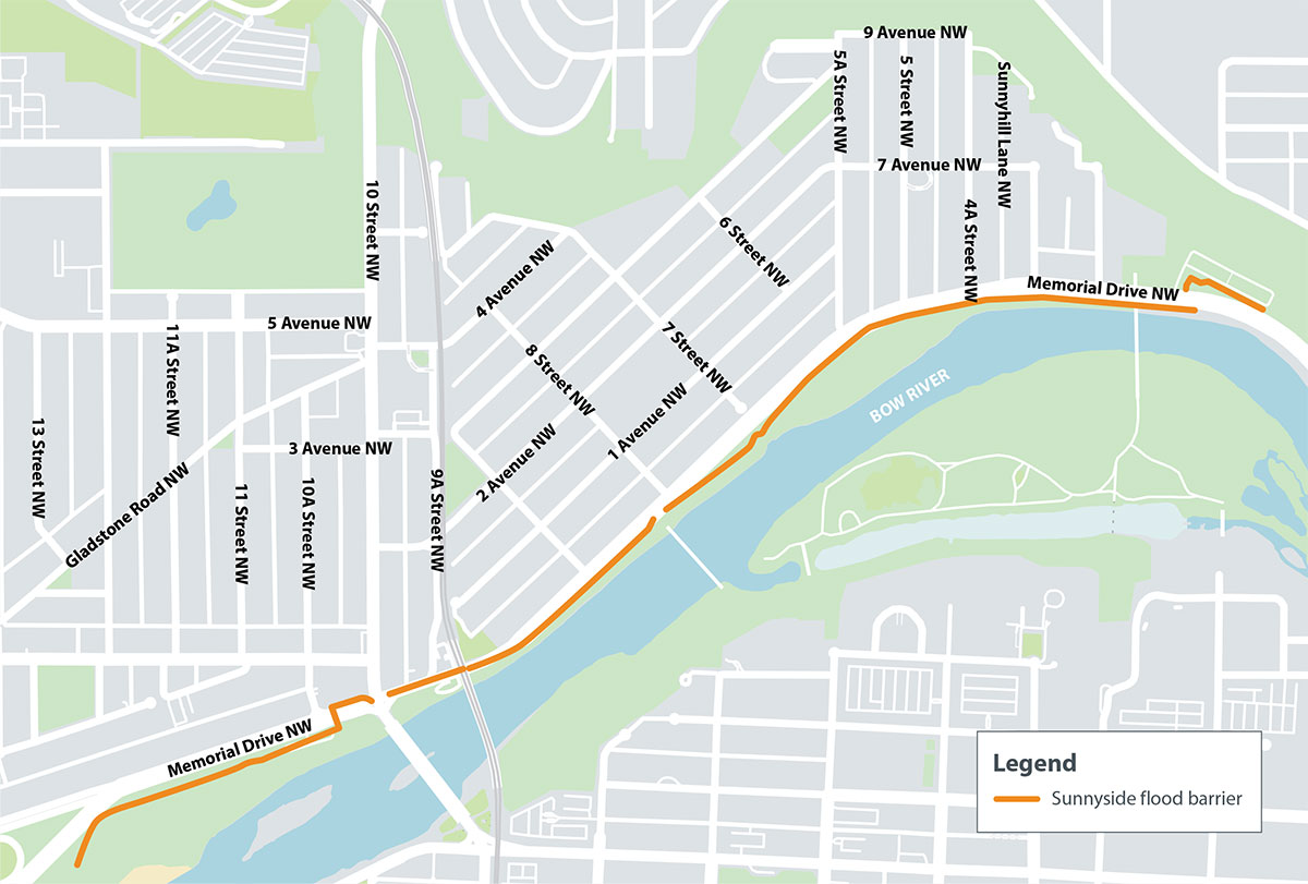
Click to enlarge image.
The barrier’s location along one of Calgary’s most cherished corridors, is an important consideration.
This space must be protected and where possible, enhanced. When designing and constructing the flood barrier, we have had a chance to build upon improvements to this area that have happened over the last 10 years and continue to improve the entire public space surrounding Memorial Drive N.W. from 14 St. to Centre Street while adding critical flood protection.
The new flood barrier will also provide the building blocks for future climate resiliency.
Work happening this year
| Location | Closure Details | Status and Anticipated Schedule | Impact |
|---|---|---|---|
| Eastbound Memorial Drive between 10 St and Centre St N.W. | Eastbound lanes will be closed, all eastbound traffic will be detoured to one westbound lane. | April – October 2025 | One westbound lane and one eastbound lane will remain open per direction. Expect delays. |
| 7 St N.W. to Prince’s Island Park Pedestrian Bridge | Full closure of the pathway. | April – October | Pedestrian traffic will be detoured to the sidewalk on the north side of Memorial Drive N.W. |
| Peace Bridge to 7 St N.W. |
Full closure of the pathway. |
May – September |
Pedestrian traffic will be detoured to the sidewalk on the north side of Memorial Drive N.W.
Access to the Peace Bridge will remain open throughout construction via 9 St N.W. or 7 St N.W. |
| 14 St N.W. to Poppy Plaza | Full closure of the wheeling pathway. | July – October | Wheeling traffic will be detoured to the south (downtown) Bow River Pathway. |

Please note: Construction will typically take place Monday to Saturday from
7 a.m. -7 p.m., however there may be construction taking place on Sundays
from 7 a.m.- 7 p.m. as needed to ensure work remains on schedule.
During construction, sections of the Bow River Pathway between 14 St N.W. and Centre St will be impacted. During this time, pathway users will be provided detours to ensure safety and connectivity.
What will the Sunnyside Flood Barrier look like?
The flood barrier will include a combination of permanent flood walls and sheet walls as well as temporary deployable systems (i.e., sandbags, water filled tubes) and demountable flood walls. The barrier will be approximately 2.4 kilometres long.
Click on the buttons below for a virtual tour of the future Sunnyside flood barrier and public realm improvements.
Sheet Pile Flood wall
A permanent metal wall that is designed to hold back flood water. It is embedded below ground three-six metres deep to provide structural stability. The sheet pile wall is designed for space-constrained areas and minimizes the amount of construction disturbance and tree/shrub removal. Sheet pile is not recommended for certain areas of the barrier where it risks inhibiting the flow of groundwater from the community subsurface aquifers to the river. About half of the wall is made of sheet pile.

Concrete Flood wall
A permanent, freestanding wall, made of concrete, designed to hold back flood water. Concrete flood wall is another space-conscious barrier type but one that requires more construction disturbance area to excavate and place the concrete base. Concrete flood walls have been designated for areas that require free movement of groundwater beneath.

Tree inventory and Removal
Removing a tree is always a last resort. However, to make improvements in the area, some tree loss is unavoidable. Approximately 200-250 tree removals are required as part of the project. 35 of those trees were removed in 2024 with the remainder being removed in 2025.
Many trees will be repurposed in:
- Fish compensation projects
- Habitat restoration work for fish and wildlife
- The construction of planting beds and seating around Sunnyside and around Prince’s Island
In advance of the enabling works and main construction, our team took inventory, surveyed and completed heath assessments of each tree on site. We plan to replant 250 new trees and new flowers and shrubs. We have also made modifications to the original design of the flood barrier to minimize required tree removals.
For more information on Memorial Drive Trees, please visit Memorial Drive trees.
Bow River flooding - what's the risk in Sunnyside?
Homes, buildings and other infrastructure in Sunnyside are impacted when river flows reach levels of 927 m3/s (1:10). There is a 10 per cent chance of this occurring every year. Find out if your property is at risk of flooding.
What measures will protect Sunnyside from future flooding?
To protect Sunnyside from future flooding, the Flood Mitigation Measures Assessment (FMMA) report, approved by Council in spring of 2017, recommended that a combination of mitigation solutions that work together to create a flexible and adaptable flood risk management program. Each piece of the strategy provides great benefits independently, but together, they ensure the most effective flood protection strategy.
Below is a summary of this multi-measure approach to building flood resiliency that includes the construction of a new upstream reservoir, as well as changes to the TransAlta’s Ghost Reservoir and the construction of community-level flood barriers.
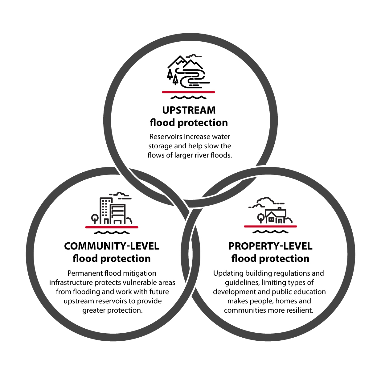
Learn more about Calgary's Flood Mitigation and Resiliency Plan.
What is the level of protection for the barrier?
After working with the community and completing a Triple Bottom Line evaluation to explore different options for a flood barrier in Sunnyside, Council approved the 1 in 100-year flood barrier height that will help protect people, homes and businesses in Sunnyside/Hillhurst from river flooding.
Benefits of the 1:100 year flood level barrier height
- Reduces the 2013-level flood risk, which will be further reduced by current and future upstream reservoirs on the Bow River.
- Less disruptive to the community look and feel
- Increases the ability to protect vulnerable populations
- Meets the provincial and federal flood standard (1 in 100-year)
- Provides the building blocks for future climate resiliency
The 1 in 100-year barrier for Sunnyside was determined to be the best balance between social, environmental and economic considerations When constructed, it will immediately reduce Sunnyside’s risk from a 2013-level flood.
Is the barrier expandable to a 1:200-year service level?
Following direction from Council, the barrier will be built to withstand the 1:100-year flood event having a peak flow rate of 2090 m3/s at Sunnyside. This is greater than the recorded peak flow rate of the 2013 flood that was 1840 m3/s. The 1:200-year event peak flow rate is 2710 m3/s. To withstand the 1:200-year flood the barrier would need to expand in length by approximately 1 km and in height by 0.7 m along its entire length.
Still, designers investigated modifying certain components of the flood barrier to simplify possible future expansion of the barrier within its footprint and within its approved budget. Wider concrete footings, deeper pile depths and greater vegetation setbacks were considered but did not offer appreciable current benefit (i.e. not cost effective) for a possible future expansion.
Also, for a given length and height, there are numerous consequent design decisions that would need to be reconsidered if the level of service was to be increased. Such considerations are better addressed at the time of expansion, if deemed necessary.
Will the City impose any building restrictions in Sunnyside and Hillhurst if the barrier is not sized protect from a 1:200 flood?
The City is exploring how to regulate land use in river valleys through the Calgary River Valleys Project This work follows, the Government of Alberta’s update of Flood Hazard Area maps for communities across the province. This will ultimately lead to an update of the Land Use Bylaw. Flood Hazard maps are based on the 1:100-year flood and include ‘protected areas’ where flood protection is provided, such as Sunnyside and Hillhurst. Appropriate regulation for such areas is being explored. Land use regulation may change in Sunnyside or Hillhurst, but it is not affected by the barrier’s height above the 1:100-year flood.
Addressing other sources of flooding in Sunnyside
Due in part to the geography as well as an outdated drainage system, Sunnyside is more prone to flooding and this is something that The City is working to fix. In addition to the flood barrier, several projects have been completed or are currently underway to reduce flooding that happens in the community.
Visit Calgary.ca/sunnysidecdi for a list of projects and up to date information.
Is the location of the flood barrier finalized?
Yes. The barrier will run south of Memorial Drive between west of Centre St to 14 St NW. Please refer to the map above for more information of its location.
Renderings are being developed for key locations to provide more information on how the barrier integrates with the current spaces.
How is The City coordinating with other projects in the area?
As we advanced the flood barrier design, we recognized the significant impact this project would have on the area. During this time, it also uncovered some opportunities to integrate the flood barrier into other work that was happening in this area and a desire to capitalize on this moment to protect and enhance the area as much as possible while adding the flood protection.
To help increase flood resiliency and create spaces that enhance the connection with the river, natural environment and commemorate our heritage, we’re combining this work through an integrated program. We recognized that by taking a more integrated approach we could achieve the best outcome for the area.
What flood protection is provided to Sunnyside residents in the meantime?
As part of The City’s emergency response plan, we are ready to respond, if needed, in areas that are still vulnerable to river flooding. We stockpile riverbank protection and temporary barrier materials and each spring our City teams review their plans, conduct site visits and train crews.
In addition, every spring, infrastructure such as water main valves, stormwater outfall gates, lift stations and pump are prepared, tested or positioned for flood season to reduce potential damages during a flood.
Why is the flood barrier being built to include Hillhurst from 10 St to 14 St N.W. given this area did not experience flooding in 2013?
While the 2013 flood did not impact Hillhurst, The City, through community engagement , determined that a 1:100 year flood barrier would be the safest and most effective decision for this area long-term.
In order to achieve this 1:100 year flood barrier, it is required to include 10 St to 14 St N.W. By doing so, this also allows Hillhurst to be designated as a ‘protected area’ on the provincial Flood Hazards maps.
What is the anticipated height of the flood barrier between 10 St and 14 St N.W.?
The average height of the flood barrier along this stretch is approximately 1.1m. It will largely be made up of sheet pile wall with some concrete sections throughout.
As part of this project, will The City install a pedestrian crossing at 8 St N.W. and Memorial Drive to mitigate illegal pedestrian crossings at this location?
During the Peace Bridge development phase of the flood barrier project, we engaged with the communities about their preferences for pedestrian crossings along Memorial Drive. . As a result of this engagement, it was decided that the community’s preference would be to maintain the existing pedestrian crossings at 7 St and 9 St N.W. rather than including one at 8 St N.W.
The flood barrier and landscape design east of the Peace Bridge has considered this and will include deterrents such as a concrete wall with a railing and boulders to discourage individuals from scaling the flood barrier and attempting to illegally cross Memorial Drive at 8 St N.W.
Stay connected
Sign up for our email updates to receive the most up-to-date information about Memorial Parkway Program Improvement projects.
Have questions or concerns about project construction?
Newsletters
View recent project updates: