Frequently asked questions
Why was the Development Map created?
The Development Map was created to enable citizens and community associations to provide comments on planning applications in their communities in a more easily accessible and convenient manner.
The City can then use these comments to provide applicants with direction on their application.
This is expected to lead to better development outcomes in communities and may lead to buildings that better reflect important community values and the character of the neighbourhood.
What are the benefits of the Development Map?
- Enables you to see development permit application plans/renderings without submitting a service request to Property Research.
- Final approved plans will be posted to allow you to see how the development changed based on feedback from interested parties, including citizen comments.
- Makes it more easily accessible and convenient to participate in the planning process.
- Enables you to provide your personal comments directly to the file manager without the assistance of someone from the community association.
- Allows you to follow progress on an application, see the status, and know if and when there are public meetings that you can watch or participate in.
Will the Development Map replace the current methods of communicating about development applications?
The Development Map is an additional resource created to enhance current circulation, notification, and outreach practices. It is critical that citizens continue to be informed and have channels through which to view, understand, and offer feedback on development applications that may impact their communities.
We will continue to post signage (notice postings) on or near sites where a land use or development application has been received by The City with the intention of encouraging the public to learn more and to provide their thoughts.
Additionally, we will continue to provide notice to community associations through the circulation process.
How long is a development application available on the Development Map?
The application information will stay on the mapping system for approximately two years. However, plans and renderings that have been submitted with an application will only be available for viewing from the time of submission and for a few weeks following the decision date. To view application plans outside this timeframe please contact propertyresearch@calgary.ca
Why can’t I see the comment button on an application?
- The commenting period is not open. If the comment button is not available, the application is not within the comment period set out by either the Municipal Government Act (MGA) or the Land Use Bylaw (LUB)
- A decision has already been made on the application (approved/refused). You can check to see if this is the case by clicking on the Details button on the application and then using the Status button to view the current status of the application. When the decision/outcome box is checked that means a decision has been made and the commenting period is now closed.
Why can I only see some of the application information that has been submitted?
Some information is not permitted to be shown publicly as per our Freedom of Information and Protection of Privacy (FOIP) policy. An example of this is, an applicant or homeowner’s personal information.
The plans and renderings that are shared provide information to help you understand how a development may impact you and your community. The intention of making the plans and renderings available is to help you understand how a development may impact you or your community.
You will only see the plans that are considered relevant to the engagement process. For example, you will see the exterior plans for a new home but the internal plans, which may include the number of bedrooms, are not included.
This information will not be shared as interested parties, including The City, cannot legally comment on how individuals choose to build out their dwelling space.
Who do I contact if I need help understanding the application?
For questions about land use redesignations (rezonings), Development permits, building permits, and business licensing:
Planning Services Centre
(403) 268-5311
Calgary.ca/livechat
planninghelp@calgary.ca
For more information about a specific application, contact the file manager using the contact us tab in the detailed application information.
Other resources
Land Use Bylaw - commonly used terms
Land use redesignations
Each property within the City of Calgary is associated with a land use district (commonly known as zones). Each district outlines a list of uses a property can be (like a home, or a retail shop), as well as what can be built on the land. If a property owner wishes to use the property in a way that’s not listed in their zone, they can apply for a land use redesignation for City Council’s approval.
The land use redesignation process enables the public to have input on this type of applications submitted to The City, which helps to inform the recommendation that is presented to the Calgary Planning Commission (CPC) – a commission who acts as the Development Authority for these matters. The CPC puts forward their recommendation to City Council and a Public Hearing is scheduled, where the general public can give feedback on the application. City Council is the only governing body that has the authority to approve, or refuse, this type of application, as outlined in the Municipal Government Act.
Note: The City of Calgary can also apply for land use redesignations (for both City and privately-owned properties). In most cases, when The City’s interested in rezoning an area that is not City-owned, it involves several properties and would contact each property owner directly.
For additional information, the land use redesignation process is outlined in the Municipal Government Act and The City’s Land Use Bylaw.
Development Permit (DP)
Development Permits are applied for when a property owner would like to change the existing building or use of the building, which can include intensifying an existing use. This application type allows for The City to review the existing conditions, identify potential impacts due to the change, involve impacted parties to consider their concerns, and ensure that changes align with any City or community policies and objectives. Development Permits refer to the rules and regulations found in the Land Use Bylaw but can also consider City planning policies. Common applications can include:
- Change of use (example – when a retail store changes to a medical office)
- Relaxations
- New buildings (any new building would require a Development Permit)
- Large scale site drainage changes
Permitted versus discretionary uses
Within the Land Use Bylaw, use’s fall under two categories; permitted or discretionary.
Permitted uses are uses that complement each other or are anticipated to work together. For example, in residential areas, both residential homes and garages/sheds are both listed as permitted uses. Unless a relaxation to the rules is requested, The City cannot consider additional City or community policies, and community feedback, nor can they use discretion on the outcome. If a project falls under a permitted use and does not require any relaxations, then it must be approved. Relaxation may be requested, though the relaxation allows for City discretion, public feedback and policies to be considered.
Discretionary uses are uses that may work well with the permitted uses, however depending on the site and site conditions, the use may not work. The City may review community and City policies, as well as community feedback in order to determine if a discretionary use should be approved. The City may impose their professional planning discretion to ensure a positive outcome. For example, a bed and breakfast is listed as a discretionary use in a residential area. This use of a home fits within the context of residential streets however it may require more onsite parking or privacy screening to ensure there is no negative impacts on the neighbouring properties. The City may use their discretion to review the plans and request changes that would ensure the change would have minimal impact on the neighbours.
Relaxation
Relaxations occur when a project is requesting to go above and beyond the standard rules/requirements of that area or use. Typically, this is applied for due to abnormal site conditions. For example, in residential areas the typical side yard of a house is 1.2m (4'). Older homes did not have this requirement, therefore may have been built closer to a side property line. If this homeowner were to build a deck off the back of their home inline with their house, they would have to request a relaxation as decks are required to also be 1.2m (4’) away from a property. By granting this relaxation The City would be determining that the deck makes sense to be able to go closer to the property line as it would align with the home and allow the homeowner to utilize their property in a typical manner.
Note: a use identified as Contextual cannot request a relaxation.
Calgary Planning Commission (CPC)
Calgary Planning Commission (CPC) is a committee of councillors and peers that makes recommendations on land use redesignation and road naming applications and is the decision authority for outline plans and major development permit applications. These meetings can be viewed by everyone, but the public must wait until the Council public hearing to send letters or speak.
Public hearing
Public hearings are a form of public engagement that allows the public/impacted parties to speak in front of council for 5 mins to voice their comments/concerns. Only specific planning files require a public hearing – Land Use Redesignations. A public hearing would take place at a Council meeting and any persons wishing to speak will have opportunity to speak, which means this overall form of engagement has no defined timeframe.
Advertising period
Applications that require The City to use discretion in their decisions are required to have their outcome advertised. This allows the public/ impacted parties to be notified of The City’s decision. This advertising period is stipulated by the Municipal Government Act (MGA) and would identify where the decision or the conditions of the decision would be appealed to.
Appeals period (Pending appeal)
Once The City makes a decision on an application, the decision or conditions imposed on the decision can be appealed by either the impacted people(s) or the applicant(s). Appeals are submitted to one or two appeals boards; Municipal Government Board (MGB) or the Subdivision and Development Appeal Board (SDAB). The appeal board will be identified as part of the required Advertising Period
Planning application
A planning application can come in many different forms; Land Use Redesignations, Outline Plans, Development Permits and Subdivisions. These application types will work towards setting policy that guides the potential of a property, separate land into smaller titled parcels, or even identify the specifics as to what an applicant is looking to build and how they want to use the property.
Direct Control (DC)
Direct Controls are a way to designate property so that it must follow a specific set of rules, regulations or uses that don’t apply anywhere else in the city. They can be used for projects and uses that require an extremely high level of regulation such as a zoo, sawmill, or firing-range.
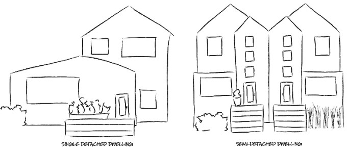
Contextual dwellings
Contextual single detached and contextual semi-detached dwellings are types of homes built within older residential communities (typically built before 2008) and follow rules that keep a similar look and feel as the street. When designated as contextual (e.g. a dwelling designated RC-1 Residential Contextual – One Dwelling Unit), it is identified as permitted use and affects the public’s ability to appeal.
Permitted use
If the building’s design follows all the rules in the Land Use Bylaw, it is considered a contextual dwelling and permitted use. The development application must be approved by The City and the public can not appeal it. The public can still make comments on contextual dwellings but they do not affect the overall outcome of the application.
Discretionary use
Discretionary use means an applicant is asking for a relaxation on Land Use Bylaw rules, or the property includes a substantial change in height. Any relaxation of rules means the development application is not a contextual dwelling. The City and the public can comment on the use of the building, and how the design may impact policies and the community, which are taken into consideration in the approval of the application. The public can appeal the outcomes to discretionary-use applications.
Understanding the contextual rules
Specific rules apply to contextual single detached and contextual semi-detached dwellings. These regulations allow for a full range of architectural styles and building forms, from traditional to contemporary designs. The design must follow the rules in the Land Use Bylaw for building elements like front façades (known as articulation, which govern how much a front façade can project or recess from the building), upper storeys, windows, balconies, setbacks and landscaping.


Contextual dwellings are allowed in most low-density land use districts within a developed area (older residential communities built before 2008). Dwellings that are contextual will have one of the following district designations:
| Designation | District definition |
|---|---|
|
R-C1L, R-C1Ls |
Residential – Contextual Large Parcel One Dwelling District R-C1L is a residential designation in developed areas that is primarily for single detached homes on large parcels. R-C1Ls is a residential designation in developed areas that is primarily for single detached homes on large parcels where homes may include a secondary suite. |
|
R-C1, R-C1s |
Residential – Contextual One Dwelling District R-C1 is a residential designation in developed areas that is primarily for single detached homes. R-C1s is a residential designation in developed areas that is primarily for single detached homes that may include a secondary suite. |
|
R-C1N |
Residential – Contextual Narrow Parcel One Dwelling District R-C1N is a residential designation in developed areas that is primarily for single detached homes on narrow or small parcels where homes may include a secondary suite. |
|
R-C2 |
Residential – Contextual One/ Two Dwelling District R-C2 is a residential designation in developed areas that is primarily for single detached, side-by-side and duplex homes. Single detached and side-by-side homes may include a secondary suite |
Properties that slope significantly on a steep hill are not qualified for contextual dwelling, but can still make a discretionary dwelling application.
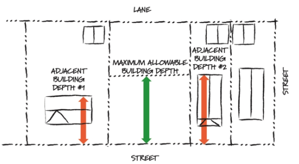
Neighbouring (adjacent) buildings
Buildings on either side of a proposed development establish contextual rules like maximum height and depth a building can be, and also how near to the street a new building may be located.
Property lines
For corner properties, the front property line is always the shortest of the two property lines facing a public street (no matter which street the house faces or is addressed). When those two property lines are equal, the municipal address determines which one is the front property line.
Where a block is curved, properties are irregular shaped or there are less than two adjacent properties, determining the correct adjacent buildings for contextual rules can be difficult. File manager at The City can assist applicants in determining the correct method.
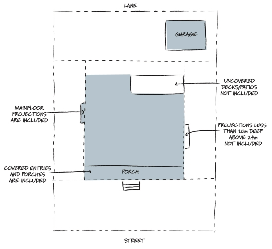
Parcel coverage
Parcel coverage is the total area of buildings located on the property. For contextual dwellings, this lot coverage depends on the district the building is in.
Maximum parcel coverage by district
R-C1, R-C1s and R-C2: 45%
R-C1L and R-C1Ls: 40%
R-C1N: 45% or 50%, if the parcel has an area less than 300m2 and a width less than 10 m.
Tree planting requirements
Trees are not required to be shown at the time of permit approvals but must be planted within a year of the development completion permit (a permit that allows The City’s Development Inspectors to inspect that a structure was built according to its development permit), so future homeowners can landscape their private yards. Trees can be existing or new, and the number required is based on the dwelling type and property width.
| Dwelling type | Property width | Required trees |
|---|---|---|
|
Single detached |
Over 10 m 10 m or less |
3 2 |
|
Semi-detached |
N/A |
2 per unit |
To encourage preservation of mature trees, existing trees on the property of a minimum size count towards fulfilling the requirements:
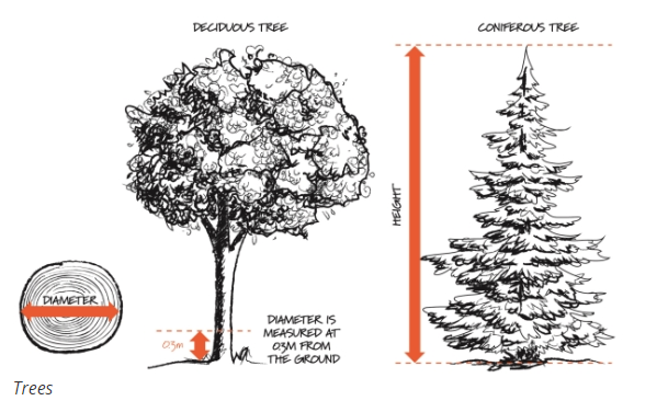
- A deciduous tree 60 mm in diameter or a coniferous tree 2 m high = 1 tree
- A deciduous tree 85 mm in diameter or a coniferous tree 4 m high = 2 trees
Deciduous trees are measured on the trunk, 0.3 m up from grade and coniferous trees are measured by height.